Skip to content
Industrial UWB RTLS for Real-Time Visibility
Menu

URTC — Vehicle Positioning Terminal

The URTC Vehicle-Mounted Hybrid Positioning Terminal integrates RTK centimeter-level positioning, optional UWB <30 cm indoor positioning, and a GNSS full-constellation system, enabling high-precision positioning for industrial vehicles, engineering machinery, cranes, and fleet applications. With a separated-module design using coaxial cable connection, the URTC terminal achieves RTK accuracy of ±3 cm, supports 4G full-netcom communication, anti-collision functions, and performs reliably in harsh industrial environments with IP67 protection, wide temperature tolerance, and strong signal reception.

SKU: URTC001
A vehicle host unit, GNSS antenna, and coaxial cable are displayed separately on a white background with labels.

Transmission & Network

Primary Transmission
Ethernet (RJ45)
Network Topology
Wired

At-a-Glance

Positioning Accuracy
RTK: Horizontal ±3 cm + 1 ppm; Vertical ±5 cm + 1 ppm
Positioning Technologies
UWB, GNSS/Beidou
Communications & Interfaces
RJ45 (Ethernet), 4G, 5G
Hot-swappable Battery
No
Ingress Protection
IP67
Operating Temperature
−40°C to +80°C
Dimensions
151 × 141 × 49 mm
Weight
<1.2 kg
Accuracy: 3cm
Range: 100m
Temp: -40~80°C
Weight: 1200g

Description

Overview

The URTC Vehicle-Mounted Hybrid Positioning Terminal (Model HXZK-URTC) is an industrial-grade positioning device designed for high-precision tracking of vehicles, cranes, engineering machinery, and factory/yard mobile equipment.
It supports RTK centimeter-level outdoor positioning, optional UWB sub-meter indoor positioning, and GNSS full-constellation navigation, making it ideal for applications requiring continuous and highly accurate tracking across mixed indoor–outdoor environments.

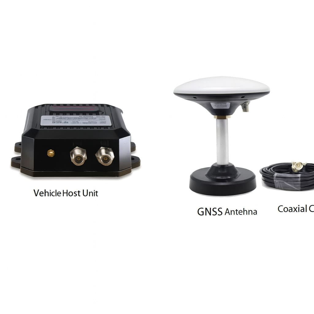
The terminal adopts a separated architecture—a vehicle host unit, GNSS/UWB antennas, and coaxial cable connection—delivering stronger signal reception and easier installation on large machinery.


Hybrid Positioning System Architecture

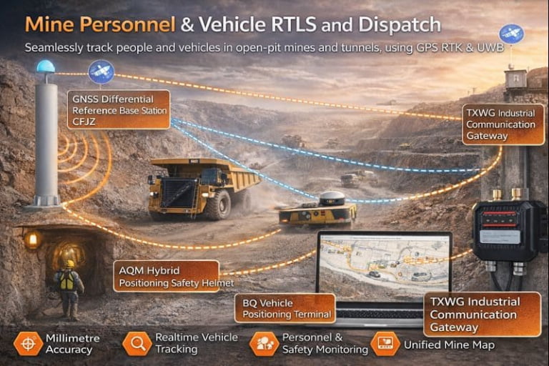
The URTC terminal supports a three-layer fused positioning architecture:

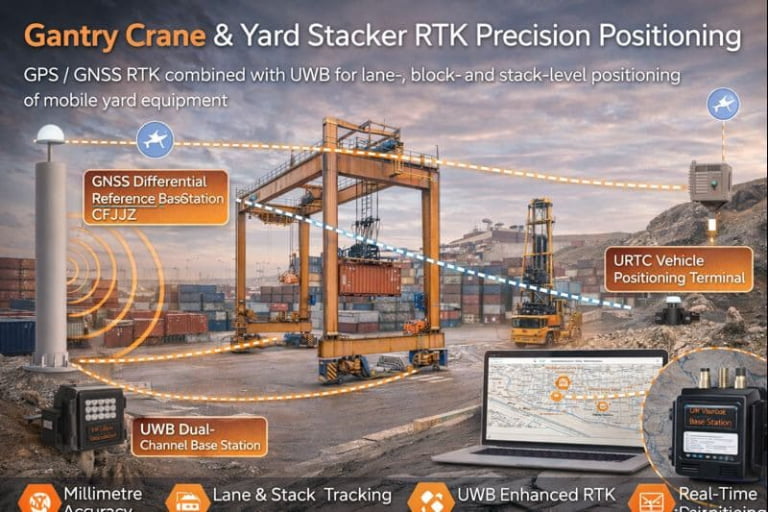
① Outdoor RTK + GNSS High-Precision Layer

  • Uses RTK correction data for centimeter-level accuracy

  • Ideal for open-sky environments such as ports, mining areas, construction zones

  • Accuracy:

    • Horizontal: ±3 cm +1 ppm

    • Vertical: ±5 cm +1 ppm

② Indoor / Zone UWB Precision Layer (Optional)

  • UWB <30 cm accuracy for indoor scenarios

  • Suitable for:

    • Workshops

    • Warehouses

    • Crane hoisting areas

    • Vehicle anti-collision zones

③ Unified Communication Layer

Supports multiple industrial communication mechanisms:

Communication Description
4G Full-Netcom Real-time data transmission
5G (Optional) Low-latency, high-throughput communication
RJ45/Ethernet Wired industrial communication
UART Integration with vehicle controllers

④ Cloud / Server Layer

  • Real-time data reporting

  • Operation logs & historical playback

  • Geofence alerting

  • Crane anti-collision algorithm

  • Vehicle-to-vehicle proximity alerts

⑤ Application Layer

  • Vehicle anti-collision

  • Crane boom collision avoidance

  • High-precision vehicle navigation

  • Yard positioning

  • Tunnel or mining equipment positioning


Separated Component Design

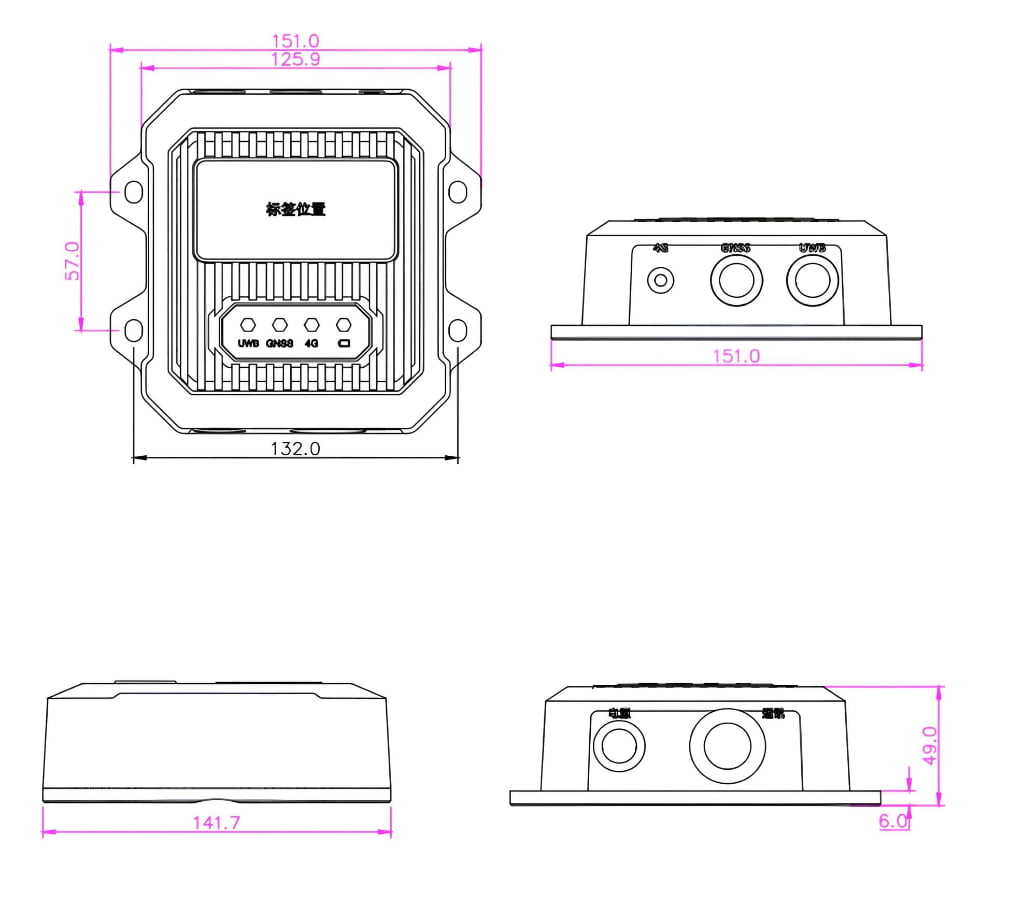
Vehicle Terminal Host Unit

  • Handles RTK/GNSS processing

  • Provides real-time output through 4G/Ethernet

  • IP67 aluminum alloy enclosure

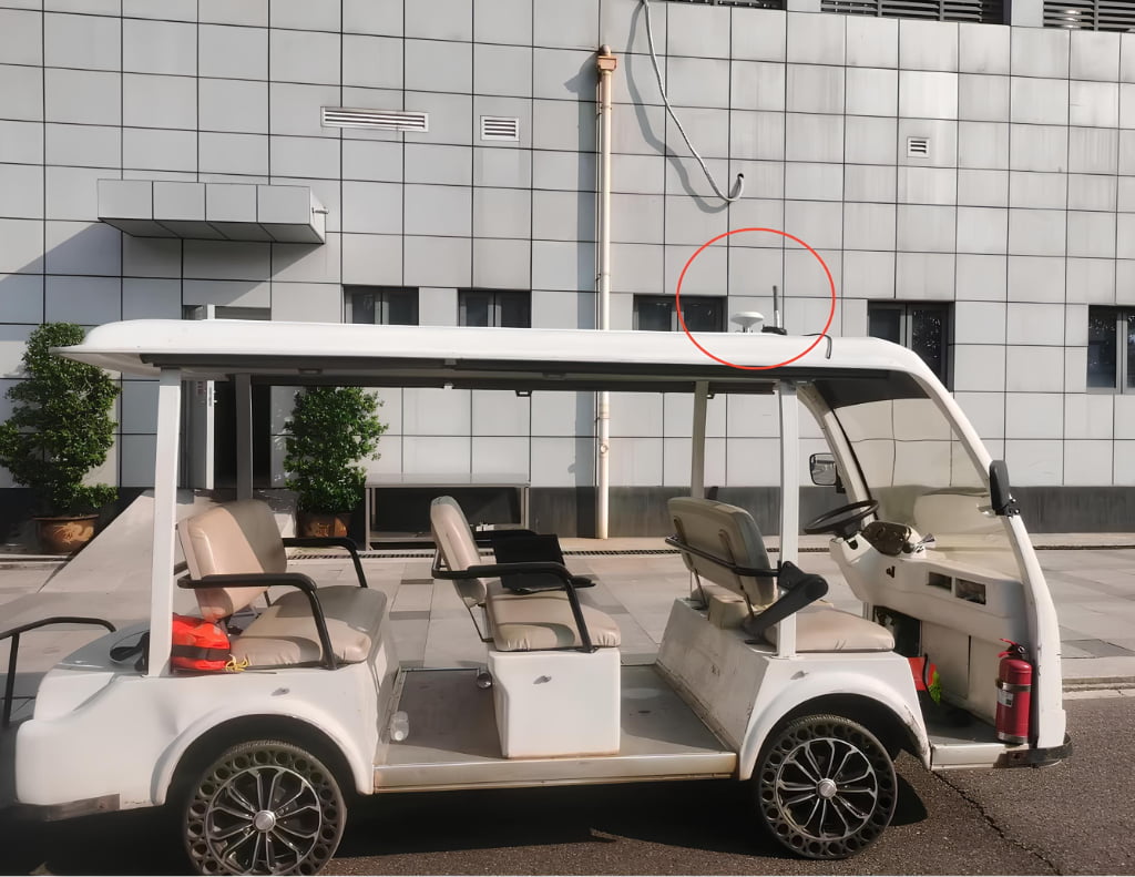
GNSS High-Gain Antenna

  • Installed on roof of vehicle

  • Connected via coaxial cable

  • Strong multipath resistance

Optional UWB Antenna

  • For indoor / semi-outdoor accuracy <30 cm

  • Supports anti-collision zones


Industrial Reliability

  • Wide temperature: −40°C to +80°C

  • IP67 enclosure

  • Strong vibration resistance

  • Surge & static protection

  • Supports long-term outdoors operation


Applications

  • Port yard vehicles

  • Mining dump trucks

  • Tunnel construction vehicles

  • Crane & hoist positioning

  • Factory AGV/IGV systems

  • Chemical industry park vehicles

  • Golf carts / patrol vehicles

  • Engineering machinery


Specifications

Power InputDC 12–24V
Positioning SystemGNSS full constellation
LED Indicators4
RTK Frequency1–20 Hz
RTK AccuracyHorizontal ±3 cm + 1 ppm; Vertical ±5 cm + 1 ppm
Fixed Solution Time≤ 10 s
Tracking Sensitivity−165 dBm
Acquisition Sensitivity−148 dBm
Device Size151 × 141 × 49 mm
Weight−40°C to +80°C
Operating Humidity0–90% RH (non-condensing)
Protection RatingIP67
Communication Mode4G full-netcom (5G optional)
Communication InterfaceRJ45 / UART
GNSS & UWB Antenna PortN-female
4G Antenna PortSMA-female
UWB Accuracy<30 cm (LOS)
UWB Range>100 m
UWB Frequency1–20 Hz adjustable

Values are typical unless stated otherwise.


Wiring & Connections

Connectors

RJ45

Installation

A white golf cart is parked on the street in front of a gray tiled building. A security camera, circled in red, is mounted high on the wall above the cart.

Mechanical Drawings

Technical drawing of a rectangular device with dimensions marked in millimeters, shown from top, front, side, and bottom views.

🌍 Industries where this device is deployed

Related Technical Resources

FAQs

Procurement (Device & Data Layer)

Planning indoor–outdoor positioning? Define fusion boundaries before RFQ.<br />

Clarify fusion responsibility, output format, and transition behavior before RFQ.<br /> This helps SI teams lock fusion terminal configuration early and avoid redesign later.<br />

Ready to Deploy RTLS?

Share your site layout and accuracy needs--we'll suggest a practical setup.

Contact Us