Skip to content
Industrial UWB RTLS for Real-Time Visibility
Menu
Industry Solutions

Transportation & Rail
RTLS & Safety Solutions

Real-time safety and asset visibility for rail and transport networks.

Railways, metros and transport hubs run complex 24/7 operations with high passenger volumes, strict timetables and powerful moving vehicles. GridRTLS uses UWB indoor positioning and GPS outdoors to provide live visibility of staff, vehicles and critical assets across tracks, tunnels, depots and stations, improving safety, reliability and operational efficiency.

Transportation and rail infrastructure includes mainline tracks, metro tunnels, stations, depots, yards, workshops, control rooms and intermodal terminals. Staff and contractors work near high‑speed trains, high‑voltage equipment, moving maintenance vehicles and crowds of passengers. Many tasks, such as night‑time track possessions, tunnel inspections and depot shunting, take place under time pressure with limited visibility.

Traditional controls — radios, paper work orders, manual sign‑in and CCTV — cannot always tell operations teams exactly where each work crew is located, how close they are to live tracks, or which track sections and sidings are occupied by vehicles and equipment. When an incident occurs, reconstructing movements of people and trains can be slow and incomplete.

GridRTLS deploys rugged UWB anchors in tunnels, stations, depots and yards, combined with hybrid UWB + GPS devices for outdoor tracks and open areas. Indoors, the system can typically achieve better than 30 cm accuracy in open line‑of‑sight conditions with update rates from 1–10 Hz, suitable for collision‑avoidance and zone enforcement. Outdoors, GPS / RTK devices on locomotives, maintenance vehicles and road vehicles provide sub‑meter to centimetre‑level accuracy where required, such as for positioning near track work zones or bridges.

On a live map, operations and safety teams can see the position of work crews, vehicles and key assets, enforce virtual work limits and intrusion zones, and automatically record who was where, when. Integration with signalling, work‑order systems, access control and video platforms turns location data into a shared, auditable layer for safety, reliability and capacity planning.


📊 Key stats for this industry

Typical Network Coverage
5–50 km of track

Track sections, tunnels, depots and stations instrumented with RTLS.

Concurrent Workforce Tracked
50–1,000 personnel

Operations, maintenance and contractor staff during day or night shifts.

Vehicles & Mobile Assets Tracked
50–300 units

Trains, shunting locomotives, maintenance vehicles, road–rail vehicles and depot equipment.

Typical Indoor / Tunnel Accuracy
<30 cm

UWB-based positioning accuracy in open line‑of‑sight stations, depots and tunnels.

⚠︎

Operational challenges

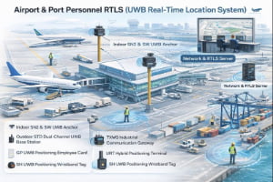
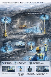
Limited real-time visibility of work crews on and near the track

During maintenance possessions, inspections and fault response, control rooms often rely on radio calls to locate crews. This makes it difficult to ensure people stay within agreed work limits and away from live lines and moving vehicles.

Risk of collision between trains, maintenance vehicles and staff

Shunting, depot operations and on‑track maintenance put people and vehicles in close proximity. Conventional signage and procedures may not prevent all near‑misses and collisions, especially in low‑visibility or complex track layouts.

Managing contractors and third parties in restricted areas

Contractors, utility workers and visitors may not be familiar with local rules or layout. Manual sign‑in and paper permits make it hard to ensure they remain within authorised zones and exit on time.

Locating trains, wagons and key assets in large yards and depots

Shunting yards and depots hold many trains, wagons and maintenance assets. Without real‑time location, staff spend time searching for the right consist, wagon, bogie set, tool or spare part.

Slow incident reconstruction and investigation

After incidents or delays, operators need to know exactly where vehicles and people were, and how they moved over time. Relying on fragmented logs and statements slows root‑cause analysis and improvement.

Business drivers

Improve worker safety on and around the railway

Real-time location, geofencing and collision‑avoidance alerts reduce the risk of staff being in the wrong place at the wrong time and support “zero harm” programmes.

Increase operational efficiency in yards, depots and stations

Better visibility of trains, vehicles and assets reduces search time, speeds up turn‑rounds and supports more precise dispatching and maintenance planning.

Strengthen compliance with rail safety regulations

Location history and exposure logs provide strong evidence for regulators and accident investigation bodies, supporting safer operating practices and standardised procedures.

Enable data-driven capacity and timetable planning

Detailed movement and dwell‑time data help planners understand real performance, refine timetables and improve use of depots, platforms and yards.

📜 Regulations & safety expectations

Rail and transport operators must comply with strict safety, signalling and occupational‑health regulations, and many networks are overseen by national safety authorities. RTLS does not replace signalling or safe‑work procedures, but it strengthens them by providing high‑quality, time‑stamped location data for people, vehicles and assets.

Deployments in tunnels and near tracks require robust hardware and careful engineering to meet standards for EMC, weather protection and, where relevant, fire safety and structural approvals. GridRTLS uses industrial‑grade anchors and tags with IP66–IP67 ratings and wide temperature ranges suitable for outdoor and tunnel environments. Location data and analytics should be governed by clear policies on access, retention and privacy, aligned with company policy and local law.

🧩 Typical RTLS use cases

Common positioning and tracking scenarios for this industry.

Track Worker & Contractor Safety

Track workers and contractors wear RTLS tags or smart helmets while working on or near the line. Control rooms see their live positions relative to work limits, live lines and approaching vehicles, and receive alerts if people enter unauthorised or unsafe zones.

Environment
mixed
Accuracy
0.3–1 m along tracks, walkways and work zones.
Update rate
1–2 s during active work.
Tracked objects
personnel, visitors_contractors
Typical integrations: Work‑order and possession‑planning systems, access control, signalling / traffic control interfaces, CCTV / VMS, safety dashboards.

Depot & Yard Vehicle Collision Avoidance

Shunting locomotives, maintenance vehicles and road vehicles are equipped with RTLS devices that measure distance to personnel tags and other vehicles in real time. Proximity alerts warn drivers and pedestrians, and event logs support safety improvement and driver training.

Environment
mixed
Accuracy
<30 cm for proximity; 1–3 m for general yard tracking.
Update rate
0.5–1 s for collision‑avoidance logic.
Tracked objects
personnel, vehicles, mobile_equipment
Typical integrations: Depot and yard management systems, fleet‑management platforms, CCTV / VMS, safety and training systems.

Train, Wagon & Asset Tracking in Yards and Depots

Locomotives, trainsets, wagons, bogie sets and key maintenance assets are tagged and tracked in real time. Staff can quickly locate specific vehicles or components by ID, type or last‑seen location, reducing search time and improving utilisation.

Environment
outdoor
Accuracy
0.5–3 m depending on yard density and use case.
Update rate
5–30 s for rolling stock and assets.
Tracked objects
vehicles, mobile_equipment, tools_pallets, materials_inventory
Typical integrations: Yard‑management systems, rolling‑stock management, maintenance and planning systems, ERP / asset registers.

Tunnel & Bridge Inspection with Smart Helmets

Inspection and maintenance teams working in tunnels, on bridges and in confined structures wear smart helmets with UWB + GPS, man‑down detection and SOS buttons. Control rooms see their precise location, receive alerts for falls or no‑movement, and can link alarms with nearby cameras where available.

Environment
mixed
Accuracy
0.3–1 m in tunnels, galleries and along inspection routes.
Update rate
1–2 s while inspection work is active.
Tracked objects
personnel
Typical integrations: Maintenance‑management and inspection systems, safety / HSE platforms, CCTV / video linkage, voice communication systems.

📋 RTLS requirements for this industry

Typical coverage
Mainline and metro tracks around key work zones, tunnels, stations, depots, yards, workshops, control buildings and intermodal terminals. Total coverage can range from a few kilometres of track for a pilot area to tens of kilometres across a dense network.
Personnel scale
From 50–200 tracked staff in smaller depots or isolated lines up to 1,000+ employees, contractors and visitors across large stations, yards and network segments, with capacity to handle peaks during major possessions or projects.
Assets & vehicles
50–300 tracked vehicles and mobile assets, including trains, locomotives, maintenance vehicles, road–rail vehicles, depot equipment and specialised inspection gear, plus hundreds to thousands of tagged tools, components and containers as needed.
Environment constraints
Rail environments combine outdoor conditions (rain, snow, dust, heat and cold) with tunnels, underground platforms and metal‑rich depots and yards. RTLS anchors and tags must tolerate vibration, weather and RF noise from signalling, traction power and communication systems, with IP66–IP67 ratings and wide operating temperature ranges. UWB’s wideband pulses help maintain accuracy and robustness around metal structures and in multipath‑prone tunnels, while GPS / RTK devices provide high‑accuracy tracking on the surface where satellite visibility is available.

🛡️ Safety & reliability expectations

Because rail networks are safety‑critical, RTLS used for worker protection and collision‑avoidance must provide sub‑meter accuracy, low latency (0.5–2 s) and high availability (target ≥99.99% for core safety functions). UWB anchors and tags can deliver <30 cm accuracy in appropriate layouts with update rates up to 10 Hz, while GPS / RTK devices provide centimetre‑level positioning for selected use cases such as precise track‑position referencing.

Battery‑powered beacons and tags need long life to minimise maintenance in hard‑to‑access locations such as tunnels, elevated structures and masts. Industrial‑grade devices in the portfolio offer multi‑year battery life at 1 Hz reporting, supporting long‑term deployments along infrastructure.

Clear governance on device management, health monitoring and data retention keeps the RTLS dependable for both day‑to‑day operations and rare emergencies.

🛰️ RTLS solutions for this industry

📦 Devices and infrastructure used in this industry

SN2 UWB PoE Anchor

SN2 UWB PoE Anchor

The SN2 is an industrial‑grade UWB positioning anchor designed for high‑accuracy real‑time location systems. It supports Standard PoE or 12–24 V DC power, delivers sub‑meter performance (<30 cm LoS), and features an IP66 enclosure for harsh indoor/outdoor environments. Multiple mounting options (ceiling, wall, pole clamp) make deployment easy in factories, warehouses, and tunnels. Optional 4G/Wi‑Fi backhaul, AI video add‑on, and sound‑light alarm extend the anchor’s capability for safety and analytics. (Actual performance depends on anchor density, layout, and site RF conditions.)

View product
SW UWB Anchor

SW UWB Anchor

The SW UWB Positioning Base Station is an industrial-grade device designed for sub-meter accuracy tracking of personnel, vehicles, and assets in factories, tunnels, and other complex environments.

View product
SH UWB Positioning Wristband Tag

SH UWB Positioning Wristband Tag

The SH UWB Positioning Wristband Tag is a high-precision wearable device designed for real-time personnel tracking and safety monitoring in industrial environments such as factories, construction sites, and tunnels.

View product
GP UWB Positioning Employee Card

GP UWB Positioning Employee Card

The GP UWB Positioning Employee Card is a compact, intelligent badge-style positioning device designed for industrial personnel management and safety monitoring. Built on UWB (Ultra-Wideband) technology, it achieves 10–30 cm accuracy, supports real-time location tracking, and enables instant SOS alerts via a one-touch button. The device includes vibration reminders, motion/static detection, and optional NFC/RFID, E-ink display, and LoRa communication modules. With an IP66-rated enclosure and 900 mAh rechargeable battery, it operates continuously in demanding environments such as factories, construction sites, logistics parks, and tunnels.

View product
UBK UWB + GPS Hybrid Positioning Badge

UBK UWB + GPS Hybrid Positioning Badge

The UBK UWB + GPS Hybrid Positioning Badge is a rugged industrial-grade personnel tracking card designed for high-precision positioning in factories, warehouses, tunnels, and other demanding environments. It integrates UWB centimeter-level positioning with GPS outdoor positioning, features SOS emergency button, motion detection, TTS voice broadcast, 4G cellular communication, and optional NFC functionality. Equipped with a 3000mAh rechargeable battery and an IP66 protection rating, the UBK badge ensures reliable real-time personnel visibility and safety monitoring both indoors and outdoors.

View product
URT Hybrid Positioning Terminal

URT Hybrid Positioning Terminal

The URT Hybrid Positioning Terminal is an industrial-grade wearable tracking device that integrates UWB high-precision positioning, RTK centimeter-level positioning, GPS outdoor positioning, and 4G wireless communication. It provides real-time personnel tracking, SOS emergency alerts, TTS voice broadcasting, motion detection, and optional NFC/Lora/5G expansion. With an IP66 rugged design and a 3000mAh magnetic-charging battery, the URT terminal is ideal for complex industrial environments such as factories, tunnels, construction sites, rail transit, and energy facilities.

View product
TXWG Industrial Communication Gateway

TXWG Industrial Communication Gateway

A high-performance LPWAN-based industrial communication gateway designed for long-distance, low-power IoT communication. It supports LORA self-organizing networking, 4G cloud transmission, GPS time sync, multi-channel data forwarding, and explosion-proof applications.

View product
GNSS Differential Reference Station

GNSS Differential Reference Station

A high-precision GNSS/Beidou differential reference station that provides centimeter-level RTK corrections and sub-meter static accuracy. Supports RTCM differential data output, 4G/WiFi backhaul, UWB optional transmission, and fully integrates with positioning platforms for mining, ports, factories, and outdoor infrastructure.

View product
URTC Vehicle-Mounted Hybrid Positioning Terminal

URTC Vehicle-Mounted Hybrid Positioning Terminal

The URTC Vehicle-Mounted Hybrid Positioning Terminal integrates RTK centimeter-level positioning, optional UWB <30 cm indoor positioning, and a GNSS full-constellation system, enabling high-precision positioning for industrial vehicles, engineering machinery, cranes, and fleet applications. With a separated-module design using coaxial cable connection, the URTC terminal achieves RTK accuracy of ±3 cm, supports 4G full-netcom communication, anti-collision functions, and performs reliably in harsh industrial environments with IP67 protection, wide temperature tolerance, and strong signal reception.

View product
AQM Hybrid Positioning Safety Helmet

AQM Hybrid Positioning Safety Helmet

The AQM Hybrid Positioning Safety Helmet is an industrial-grade smart helmet integrating UWB high-precision positioning, RTK centimeter-level positioning, GPS outdoor positioning, and 4G full-network communication. Designed for worker safety and real-time visibility, it features SOS emergency alerts, TTS voice, motion/static detection, low-battery warnings, and optional NFC / LoRa / 5G communication. With an IP56 rugged rating and a built-in 3000mAh rechargeable battery, the AQM helmet is ideal for construction sites, tunnels, factories, mining, ports, and hazardous environments requiring precise personnel tracking and safety protection.

View product
JCZD GNSS Displacement & Settlement Monitoring Terminal

JCZD GNSS Displacement & Settlement Monitoring Terminal

A high-precision GNSS-based monitoring terminal designed for real-time displacement and settlement monitoring in landslides, mining slopes, dam structures, reservoir embankments, tank subsidence, and roadbed deformation. Accuracy: ±2.5 mm horizontal / ±5 mm vertical. Supports GNSS differential positioning, 4G/RJ45 communication, fusion positioning algorithms, and outdoor IP67 deployment.

View product
WZ UWB Asset Positioning Tag

WZ UWB Asset Positioning Tag

The WZ UWB Asset Positioning Tag is a high-precision industrial tracking device designed for vehicles, tools, pallets, and other assets. It features a built-in 1800mAh rechargeable battery, powerful magnetic mounting, IP67 protection, and UWB sub-meter (<30cm) positioning accuracy. With a wireless communication range of over 100 meters, smart sleep mode, beeping alerts, and low-battery alarm, the WZ tag enables reliable asset visibility and loss prevention across factories, logistics hubs, rail workshops, and heavy-equipment environments.

View product

Frequently asked questions

How does RTLS work in tunnels where GPS signals are not available? +
In tunnels, RTLS uses UWB anchors fixed along the tunnel and platforms. Tags on people and vehicles measure ranges to several anchors, allowing the system to compute accurate positions independent of GPS.
Can RTLS be used to enforce safe work limits on or near tracks? +
Yes. Geofences can be configured to match work limits, danger zones and restricted areas. When tagged personnel cross these virtual boundaries or approach live tracks, automatic alerts can be sent to the control room, supervisors or directly to the worker’s device.
How accurate is RTLS for collision avoidance in depots and yards? +
With a correct anchor layout, UWB typically achieves around 30 cm accuracy in open depot and yard areas, which is sufficient for person–vehicle and vehicle–vehicle proximity alerts.
Will RTLS interfere with signalling or radio systems? +
UWB operates at low power using very short pulses across a wide frequency band and is designed to coexist with other radio systems. RTLS hardware is built to industrial EMC standards, and deployments are validated through site surveys and testing to confirm there is no adverse interaction.
Can RTLS data be integrated into our existing traffic control and planning tools? +
Yes. RTLS platforms provide APIs and event streams that can feed operations dashboards, planning tools, safety analytics and incident‑management systems, allowing you to reuse location data across multiple applications.

Related Technical Resources

Bring real-time location into your rail and transport operations.

Share your network map — tracks, tunnels, depots and stations — plus your key safety and operational priorities. We’ll design a UWB + GPS RTLS solution for track worker safety, collision avoidance, yard management and asset tracking tailored to your environment.

48hr Response Time
Complete Integration Docs
Remote Setup Support

Ready to Deploy RTLS?

Share your site layout and accuracy needs--we'll suggest a practical setup.

Contact Us