Skip to content
Industrial UWB RTLS for Real-Time Visibility
Menu
Industry Solutions

Industrial Maintenance & Utilities
RTLS & Safety Solutions

Real-time worker safety and asset visibility for critical industrial and utility sites.

Maintenance and utility operations run in hazardous, high‑value environments such as power plants, chemical facilities and large industrial complexes. GridRTLS combines UWB indoor positioning with GPS outdoors to provide live visibility of workers, vehicles and tools, improving safety, maintenance execution and regulatory compliance.

Industrial maintenance and utility operations support vital infrastructure — electricity generation and distribution, oil and gas processing, chemical plants, steel mills and water treatment facilities. These sites feature dense pipe racks, high‑voltage areas, confined spaces, rotating machinery and heavy mobile equipment. Work often happens during shutdowns, turnarounds or emergency repairs, involving many contractors on tight schedules.

Traditional controls such as work permits, radios and paper sign‑in sheets provide only partial oversight. Supervisors may not know exactly who is working in which zone, which contractor teams are inside confined spaces, or how close workers are to moving cranes, trucks or overhead cranes. When an incident occurs, reconstructing who was nearby and how events unfolded is time‑consuming and incomplete.

GridRTLS deploys rugged UWB anchors and wireless beacons in process units, tunnels, buildings and outdoor pipe racks, with wearable tags for personnel and vehicle‑mounted devices for cranes, trucks and forklifts. The system typically delivers better than 30 cm indoor accuracy with update rates from 1–10 Hz in open conditions, even in harsh industrial RF environments

GPS and RTK devices extend coverage outdoors across tank farms, stockyards and open pits.

The platform enables real‑time maps of workers and vehicles, geofences around hazardous zones, man‑down and SOS alarms, collision‑avoidance logic and detailed exposure reports by zone, job, contractor and time. Integration with permit‑to‑work, DCS / SCADA, video and access control systems turns location data into a central safety and operations layer.

📊 Key stats for this industry

Typical Site Coverage
10,000–500,000 m²

Process units, substations, yards, control buildings and corridors covered by RTLS.

Concurrent Workforce Tracked
100–3,000 personnel

Employees and contractors during normal operation or shutdown periods.

Mobile Assets & Vehicles Tracked
50–500 assets

Cranes, forklifts, maintenance vehicles, tools, lifting gear and temporary equipment.

Typical Indoor Accuracy
<30 cm

UWB positioning accuracy in open industrial spaces, suitable for collision avoidance and zone control.

⚠︎

Operational challenges

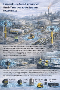
Managing worker safety in hazardous zones

Industrial and utility sites contain high‑risk areas such as high‑voltage rooms, rotating machinery, hot surfaces and confined spaces. Supervisors need continuous awareness of who is in each zone and whether they are authorised and protected.

Person–vehicle and vehicle–vehicle collision risks

Forklifts, cranes, dump trucks and other machines operate in tight spaces with limited visibility. Without accurate proximity detection, near‑misses and collisions are hard to prevent and analyse.

Limited insight into contractor activities and exposure

During turnarounds and shutdowns, hundreds of contractors enter the plant. Paper permits and manual checks do not provide real‑time visibility of where contractor teams are working or how long they stay in hazardous zones.

Locating tools, lifting gear and temporary equipment

Specialised tools, scaffolding components, lifting accessories and temporary equipment move between jobs and areas. Misplaced items cause delays, extra rentals and disputes.

Slow and incomplete incident investigation

After an incident, HSE teams must reconstruct worker movements, presence in exposure zones and equipment positions. Without reliable location history, investigations rely on interviews and partial logs.

Business drivers

Reduce incidents and improve HSE performance

Real-time location, geofencing and collision‑avoidance alerts help prevent accidents in high‑risk industrial environments and support corporate HSE targets.

Increase productivity during maintenance and shutdowns

Better visibility of worker deployment, equipment locations and zone occupancy speeds up work execution, reduces waiting time and improves coordination between teams.

Strengthen compliance and audit readiness

Accurate records of who entered each zone, for how long and under which permit help satisfy regulators, insurers and internal audit requirements.

Optimise asset fleets and reduce rental costs

Usage and location data for cranes, vehicles and tools supports right‑sizing fleet capacity and reducing unused or lost equipment.

📜 Regulations & safety expectations

Industrial maintenance and utility operations are usually governed by strict safety regulations and standards covering confined spaces, electrical safety, hazardous areas, work permits and contractor management. RTLS does not replace these controls but enhances them by providing real‑time and historical evidence for audits, incident investigations and performance reviews.

Deployments in explosive or hazardous environments may require intrinsically safe devices and certified equipment. GridRTLS hardware options include rugged, IP66–IP67‑rated anchors and tags designed for harsh industrial and explosive atmospheres, supporting continuous operation at temperatures from about –40 °C to +80 °C.

Final system design should be reviewed with site safety, electrical and instrumentation teams to ensure compliance with local regulations and company standards.

🧩 Typical RTLS use cases

Common positioning and tracking scenarios for this industry.

Worker Safety & Contractor Oversight in Process Units

Workers and contractors wear RTLS tags when entering process units or hazardous areas. Supervisors can see real‑time headcount by unit and zone, receive alerts if unauthorised personnel enter restricted areas, and use historical traces to support permit‑to‑work compliance and incident analysis.

Environment
mixed
Accuracy
0.3–1 m in production units, pipe racks and buildings.
Update rate
1–3 s for safety‑critical visibility.
Tracked objects
personnel, visitors_contractors
Typical integrations: Permit‑to‑work systems, access control, DCS / SCADA event feeds, CCTV / VMS, HSE incident‑management platforms.

Vehicle & Mobile Equipment Collision Avoidance

UWB devices on forklifts, cranes and other mobile equipment continuously measure distance to wearable tags and other vehicles. When separation falls below a configured threshold, the system issues audio/visual warnings and logs events for analysis.

Environment
mixed
Accuracy
<30 cm for short‑range proximity; 1–3 m for general vehicle tracking.
Update rate
0.5–1 s for proximity detection and alarms
Tracked objects
personnel, vehicles, mobile_equipment
Typical integrations: Vehicle control systems, fleet‑management platforms, CCTV, safety dashboards

Tool, Lifting Gear & Temporary Asset Tracking

Tags are attached to specialised tools, lifting accessories, scaffolding components and temporary equipment. Supervisors can search and locate items on a map, check where they were last used, and track utilisation during major shutdowns

Environment
mixed
Accuracy
0.5–3 m depending on asset type and zone size.
Update rate
10–60 s for assets, optimised for battery life
Tracked objects
mobile_equipment, tools_pallets, materials_inventory
Typical integrations: Tool‑room and asset‑management systems, CMMS / maintenance‑management, rental and logistics systems

Lone‑Worker Protection with Smart Helmets & Wearables

Maintenance technicians and inspectors working alone in remote areas, substations or at height wear smart helmets or badges with UWB + GPS, motion and SOS buttons. Man‑down, no‑movement or panic events trigger alarms with precise location and can automatically bring up camera views.

Environment
mixed
Accuracy
0.3–1 m around equipment, platforms and access routes.
Update rate
1–2 s while active; longer intervals in low‑risk transit zones.
Tracked objects
personnel
Typical integrations: Permit‑to‑work and job‑planning systems, security and emergency‑response platforms, CCTV / video linkage, voice communication systems.

📋 RTLS requirements for this industry

Typical coverage
Production units, pipe racks, tank farms, substations, switch rooms, workshops, warehouses, control buildings, tunnels and yards — ranging from 10,000 m² for a single facility to 500,000 m² or more for integrated plants or utility networks.
Personnel scale
Typical deployments cover 100–1,000 workers on a single site during normal operations, scaling to 2,000–3,000 people during shutdowns or turnarounds when contractor activity peaks.
Assets & vehicles
Dozens to hundreds of tracked vehicles and machines (cranes, forklifts, trucks, maintenance vehicles) and hundreds to thousands of tagged tools and temporary assets such as pumps, generators, scaffolding sets and lifting gear.
Environment constraints
Industrial and utility environments feature high temperatures, dust, humidity, vibration, electromagnetic noise and in some cases explosive atmospheres. RTLS anchors and tags must be rugged, with IP66–IP67 protection, wide temperature ranges (around –40 °C to +80 °C) and strong EMC performance. UWB’s wideband, short‑pulse signals provide high accuracy and strong resistance to interference from metal structures and other radios, while GPS / RTK receivers serve open outdoor areas and long‑range coverage.

🛡️ Safety & reliability expectations

Safety‑critical use cases (collision avoidance, man‑down alarms, hazardous‑zone monitoring) demand sub‑meter accuracy, location updates every 0.5–2 seconds and high system availability (target ≥99.99% during operating hours). UWB anchors and tags can achieve <30 cm accuracy in open conditions with configurable update rates up to 10 Hz, while RTK‑enabled GPS devices on vehicles and fixed structures provide centimetre‑level outdoor accuracy.

The system should support redundant servers and gateways, local buffering of data during network outages and continuous health monitoring. Battery‑powered beacons can operate for several years in 1 Hz modes, reducing maintenance effort in hard‑to‑access areas such as towers and pipe racks.

Clear governance around data retention, access rights and use of analytics is needed to align RTLS with internal HSE and IT security policies.

🛰️ RTLS solutions for this industry

📦 Devices and infrastructure used in this industry

SN2 UWB PoE Anchor

SN2 UWB PoE Anchor

The SN2 is an industrial‑grade UWB positioning anchor designed for high‑accuracy real‑time location systems. It supports Standard PoE or 12–24 V DC power, delivers sub‑meter performance (<30 cm LoS), and features an IP66 enclosure for harsh indoor/outdoor environments. Multiple mounting options (ceiling, wall, pole clamp) make deployment easy in factories, warehouses, and tunnels. Optional 4G/Wi‑Fi backhaul, AI video add‑on, and sound‑light alarm extend the anchor’s capability for safety and analytics. (Actual performance depends on anchor density, layout, and site RF conditions.)

View product
SW UWB Anchor

SW UWB Anchor

The SW UWB Positioning Base Station is an industrial-grade device designed for sub-meter accuracy tracking of personnel, vehicles, and assets in factories, tunnels, and other complex environments.

View product
SH UWB Positioning Wristband Tag

SH UWB Positioning Wristband Tag

The SH UWB Positioning Wristband Tag is a high-precision wearable device designed for real-time personnel tracking and safety monitoring in industrial environments such as factories, construction sites, and tunnels.

View product
GP UWB Positioning Employee Card

GP UWB Positioning Employee Card

The GP UWB Positioning Employee Card is a compact, intelligent badge-style positioning device designed for industrial personnel management and safety monitoring. Built on UWB (Ultra-Wideband) technology, it achieves 10–30 cm accuracy, supports real-time location tracking, and enables instant SOS alerts via a one-touch button. The device includes vibration reminders, motion/static detection, and optional NFC/RFID, E-ink display, and LoRa communication modules. With an IP66-rated enclosure and 900 mAh rechargeable battery, it operates continuously in demanding environments such as factories, construction sites, logistics parks, and tunnels.

View product
AQM Hybrid Positioning Safety Helmet

AQM Hybrid Positioning Safety Helmet

The AQM Hybrid Positioning Safety Helmet is an industrial-grade smart helmet integrating UWB high-precision positioning, RTK centimeter-level positioning, GPS outdoor positioning, and 4G full-network communication. Designed for worker safety and real-time visibility, it features SOS emergency alerts, TTS voice, motion/static detection, low-battery warnings, and optional NFC / LoRa / 5G communication. With an IP56 rugged rating and a built-in 3000mAh rechargeable battery, the AQM helmet is ideal for construction sites, tunnels, factories, mining, ports, and hazardous environments requiring precise personnel tracking and safety protection.

View product
UBK UWB + GPS Hybrid Positioning Badge

UBK UWB + GPS Hybrid Positioning Badge

The UBK UWB + GPS Hybrid Positioning Badge is a rugged industrial-grade personnel tracking card designed for high-precision positioning in factories, warehouses, tunnels, and other demanding environments. It integrates UWB centimeter-level positioning with GPS outdoor positioning, features SOS emergency button, motion detection, TTS voice broadcast, 4G cellular communication, and optional NFC functionality. Equipped with a 3000mAh rechargeable battery and an IP66 protection rating, the UBK badge ensures reliable real-time personnel visibility and safety monitoring both indoors and outdoors.

View product
TXWG Industrial Communication Gateway

TXWG Industrial Communication Gateway

A high-performance LPWAN-based industrial communication gateway designed for long-distance, low-power IoT communication. It supports LORA self-organizing networking, 4G cloud transmission, GPS time sync, multi-channel data forwarding, and explosion-proof applications.

View product
WZ UWB Asset Positioning Tag

WZ UWB Asset Positioning Tag

The WZ UWB Asset Positioning Tag is a high-precision industrial tracking device designed for vehicles, tools, pallets, and other assets. It features a built-in 1800mAh rechargeable battery, powerful magnetic mounting, IP67 protection, and UWB sub-meter (<30cm) positioning accuracy. With a wireless communication range of over 100 meters, smart sleep mode, beeping alerts, and low-battery alarm, the WZ tag enables reliable asset visibility and loss prevention across factories, logistics hubs, rail workshops, and heavy-equipment environments.

View product
URT Hybrid Positioning Terminal

URT Hybrid Positioning Terminal

The URT Hybrid Positioning Terminal is an industrial-grade wearable tracking device that integrates UWB high-precision positioning, RTK centimeter-level positioning, GPS outdoor positioning, and 4G wireless communication. It provides real-time personnel tracking, SOS emergency alerts, TTS voice broadcasting, motion detection, and optional NFC/Lora/5G expansion. With an IP66 rugged design and a 3000mAh magnetic-charging battery, the URT terminal is ideal for complex industrial environments such as factories, tunnels, construction sites, rail transit, and energy facilities.

View product
CJ Industrial Ranging Terminal

CJ Industrial Ranging Terminal

A high-precision industrial distance-measurement terminal supporting 1-to-1, 1-to-many, and many-to-many real-time ranging. Offers up to 10 cm accuracy, long-distance transmission (≥1000 m), strong anti-interference, IP67 protection, 24/7 stable operation, and is designed for harsh industrial applications such as overhead cranes, trolleys, mining vehicles, and material-handling machinery.

View product
FZ Industrial Collision Avoidance Radar

FZ Industrial Collision Avoidance Radar

The FZ Collision Avoidance Radar is a high-precision industrial anti-collision device designed for vehicles, loaders, forklifts, cranes, and mining trucks. It supports a detection distance over 100 meters, 30 cm accuracy, dual-relay output, strong anti-interference capability, and IP67 protection for harsh industrial environments.

View product
URTC Vehicle-Mounted Hybrid Positioning Terminal

URTC Vehicle-Mounted Hybrid Positioning Terminal

The URTC Vehicle-Mounted Hybrid Positioning Terminal integrates RTK centimeter-level positioning, optional UWB <30 cm indoor positioning, and a GNSS full-constellation system, enabling high-precision positioning for industrial vehicles, engineering machinery, cranes, and fleet applications. With a separated-module design using coaxial cable connection, the URTC terminal achieves RTK accuracy of ±3 cm, supports 4G full-netcom communication, anti-collision functions, and performs reliably in harsh industrial environments with IP67 protection, wide temperature tolerance, and strong signal reception.

View product
GNSS Differential Reference Station

GNSS Differential Reference Station

A high-precision GNSS/Beidou differential reference station that provides centimeter-level RTK corrections and sub-meter static accuracy. Supports RTCM differential data output, 4G/WiFi backhaul, UWB optional transmission, and fully integrates with positioning platforms for mining, ports, factories, and outdoor infrastructure.

View product
JCZD GNSS Displacement & Settlement Monitoring Terminal

JCZD GNSS Displacement & Settlement Monitoring Terminal

A high-precision GNSS-based monitoring terminal designed for real-time displacement and settlement monitoring in landslides, mining slopes, dam structures, reservoir embankments, tank subsidence, and roadbed deformation. Accuracy: ±2.5 mm horizontal / ±5 mm vertical. Supports GNSS differential positioning, 4G/RJ45 communication, fusion positioning algorithms, and outdoor IP67 deployment.

View product

Frequently asked questions

How does RTLS improve safety in industrial maintenance and utility sites? +
RTLS provides live visibility of workers and vehicles, geofences around hazardous areas, collision‑avoidance alerts, man‑down detection and detailed exposure reports. This helps prevent incidents and provides strong evidence for investigations and audits.
Can RTLS be used in explosive or hazardous areas? +
Yes — with appropriate hardware. Rugged, intrinsically safe anchors and tags with IP66–IP67 protection can be used in many hazardous areas, following the site’s classification and engineering standards. System design must be reviewed and approved by your electrical and safety teams.
What level of accuracy is needed for collision avoidance? +
For effective person–vehicle proximity alerts, typical requirements are better than 0.5 m accuracy at short range. UWB RTLS is well suited for this, delivering about 30 cm accuracy in open conditions when anchors are correctly positioned.
How long do tags and beacons last in harsh industrial conditions? +
Wearable tags usually operate for 1–3 months per charge at 1 Hz reporting, while battery-powered UWB beacons and asset tags can run for up to several years, depending on update interval and temperature.
Can RTLS integrate with our existing DCS / SCADA and permit‑to‑work systems? +
Yes. RTLS platforms typically expose APIs and event streams that can be linked to DCS alerts, SCADA alarms, permit systems and historian data, enabling richer safety logic (e.g. only allow equipment start when zones are clear) and automatic documentation of permit compliance.

Make your industrial and utility operations safer and more transparent.

Share your plant layout, key hazards and maintenance workflows, and we’ll design a UWB + GPS RTLS solution — from worker safety and collision avoidance to contractor oversight and tool tracking — tailored to your industrial or utility site.

48hr Response Time
Complete Integration Docs
Remote Setup Support

Ready to Deploy RTLS?

Share your site layout and accuracy needs--we'll suggest a practical setup.

Contact Us