Skip to content
Industrial UWB RTLS for Real-Time Visibility
Menu
Industry Solutions

Education & Campuses
RTLS & Safety Solutions

Real-time safety and visibility for modern smart campuses.

Universities, schools and large campuses operate like small cities, with thousands of people moving between classrooms, labs, dormitories and public spaces every day. GridRTLS uses UWB indoor positioning and GPS outdoors to give campus teams real-time visibility of students, staff, visitors and service vehicles, improving safety, emergency response and operational efficiency.

Education campuses are complex, partially open environments that must balance safety, privacy and a welcoming atmosphere. People flow through lecture halls, labs, dormitories, libraries, sports facilities and public plazas from early morning to late evening. Traditional tools such as access cards, CCTV and radios offer only limited, delayed insight into where people are and how they move, especially during emergencies or large events.

GridRTLS provides a campus‑grade real‑time location system (RTLS) using UWB anchors and wireless beacons indoors, combined with GPS positioning outdoors. Wearable tags (wristbands, ID badges, smart helmets for maintenance crews) and asset tags report positions every 1–5 seconds, with typical indoor accuracy better than 30 cm in line‑of‑sight areas.

This enables real‑time visualisation of people density, automatic alarms when someone enters restricted areas (e.g. labs, mechanical rooms, rooftops), and precise muster status during evacuations or lockdowns.

The same infrastructure can track critical assets such as lab equipment, IT carts, wheelchairs, AV trolleys and campus vehicles. Integration with access control, fire and building‑management systems, and video platforms creates a unified digital view of campus operations that supports safety, space utilisation, preventive maintenance and data‑driven planning.

📊 Key stats for this industry

Typical Campus Coverage
100,000–1,000,000 m²

Combined building interiors, open areas, sports fields and parking zones covered by RTLS.

Concurrent Population Tracked
1,000–20,000 people

Typical range of students, staff and visitors monitored in real time on large campuses.

Buildings Covered
10–80 buildings

Academic blocks, labs, dormitories, libraries and sports venues connected to the RTLS.

Typical Indoor Accuracy
<30 cm

UWB-based positioning accuracy in line-of-sight conditions for personnel and asset tracking.

⚠︎

Operational challenges

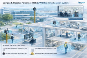
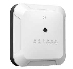
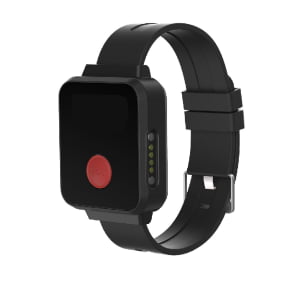
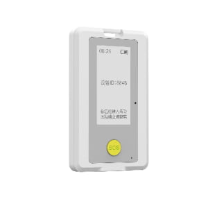
Limited real-time awareness during emergencies

Fire alarms, evacuations or lockdowns require fast confirmation that everyone has reached a safe area, but most campuses rely on manual roll calls or static access logs that do not show who is still inside a building or where they were last seen.

Controlling access to labs and restricted areas

Science labs, chemical stores, data centres and rooftops require strict access control. Conventional card systems cannot guarantee that only authorised persons remain in a zone, nor can they easily prove how long they stayed or whether they were alone.

Visitor and contractor supervision

Short-term visitors, vendors and contractors often move without escorts, making it difficult to ensure they only enter approved areas, follow safety rules and leave the campus on time.

Loss and under‑utilisation of shared campus assets

High‑value shared assets such as AV carts, lab instruments, wheelchairs and maintenance equipment are frequently misplaced, left in the wrong building or under‑utilised because their location is unknown.

Protecting lone workers and after‑hours staff

Security guards, laboratory staff and maintenance technicians often work alone at night or in remote areas of campus. Without continuous location awareness and man‑down detection, incidents can go unnoticed for too long.

Business drivers

Strengthen campus safety and duty of care

Real-time visibility, automatic alarms and incident replay capabilities help campus management demonstrate proactive safety measures and faster response to events.

Improve emergency preparedness and evacuation performance

RTLS-based muster and last‑known‑location features reduce confusion during drills and real incidents, and provide concrete evidence for post‑event reviews and regulatory reporting.

Optimise utilisation of space and shared resources

Location analytics show how buildings, rooms and shared equipment are actually used, helping facilities teams plan timetables, cleaning cycles, maintenance and future investments.

Enable data-driven “smart campus” initiatives

A common positioning layer supports integration with digital twin platforms, building‑management systems, energy optimisation and AI‑based planning tools.

📜 Regulations & safety expectations

Educational institutions must comply with local regulations and policies covering student safety, fire and building codes, and increasingly strict data‑privacy rules. RTLS does not replace these obligations but provides a richer data source for demonstrating compliance — for example by documenting access to hazardous labs, emergency drill performance and evacuation times.

Deployments should be designed with privacy‑by‑default principles: clear communication to students and staff, role‑based access to personally identifiable information, configurable data‑retention periods and options for pseudonymous or aggregated analytics where detailed tracking is not required. Consult your legal and compliance teams to align RTLS usage with local law and institutional policy.

🧩 Typical RTLS use cases

Common positioning and tracking scenarios for this industry.

Student & Staff Safety Monitoring

Students, staff and visitors move across campus throughout the day, and traditional head‑counts or card records cannot show their live location. RTLS provides real‑time visibility and automated mustering during drills or incidents, helping confirm who is safe and who may still need assistance.

Environment
mixed
Accuracy
0.3–1 m for personnel in buildings and key outdoor areas.
Update rate
1–3 s
Tracked objects
personnel, visitors_contractors
Typical integrations: Access control, fire alarm systems, building‑management systems, security dispatch, CCTV / VMS.

Laboratory & Hazardous Area Access Control

Research labs, chemical stores and mechanical rooms require clear, auditable control of who enters, how long they stay and whether they follow safety procedures. RTLS strengthens card-based access control with real‑time zone monitoring, automatic alerts and detailed entry/exit history.

Environment
indoor
Accuracy
0.3–1 m to distinguish lab rooms, benches and storage areas.
Update rate
1–5 s
Tracked objects
personnel, materials_inventory, visitors_contractors
Typical integrations: Access control, lab‑management systems, permit‑to‑work, CCTV.

Campus Vehicle & Service Fleet Tracking

Campus shuttles, service vehicles and grounds‑maintenance equipment operate across open roads, pedestrian areas and parking structures. RTLS combines GPS tracking outdoors with UWB in enclosed areas to improve visibility, routing and safety near pedestrian zones.

Environment
outdoor
Accuracy
1–3 m for vehicles outdoors; <1 m in high‑risk shared spaces.
Update rate
1–5 s
Tracked objects
personnel, vehicles, mobile_equipment
Typical integrations: Fleet‑management / telematics, maintenance systems, CCTV, traffic‑control systems.

Maintenance & Lone Worker Protection with Smart Helmets

Facilities and utilities teams work in technical areas such as roofs, tunnels, boiler rooms and electrical substations, often alone or after hours. Smart helmets with integrated UWB + GPS and man‑down detection provide continuous location, panic buttons and automatic alerts for falls or prolonged inactivity.

Environment
mixed
Accuracy
0.3–1 m around critical equipment and fall‑risk zones.
Update rate
1–2 s for active work; 5–10 s in low‑risk transit.
Tracked objects
personnel, mobile_equipment
Typical integrations: Work‑order / maintenance systems, safety management platforms, CCTV / video linkage, voice communication systems.

📋 RTLS requirements for this industry

Typical coverage
Entire campus footprint including academic buildings, libraries, labs, dormitories, sports facilities, parking structures and key outdoor walkways. Typical deployments range from a few buildings (single school) to 100+ hectares across multi‑site universities.
Personnel scale
From a few hundred staff and students on smaller campuses to tens of thousands of people on large universities, with RTLS typically focused on high‑risk groups such as lab staff, security, maintenance teams and residents in specific dormitories.
Assets & vehicles
Dozens to hundreds of tagged campus assets such as lab equipment, IT carts, AV trolleys, wheelchairs and maintenance tools, plus 10–100 vehicles including shuttles, security cars and service trucks.
Environment constraints
Campuses combine dense indoor environments (reinforced concrete, metal‑rich lab areas) with open outdoor spaces and partial “urban canyon” effects between high‑rise buildings. RTLS equipment must tolerate varying temperatures, humidity, dust and occasional outdoor exposure; UWB anchors and tags are typically IP66–IP67 rated and designed to maintain accuracy despite RF noise from Wi‑Fi and other campus systems.

🛡️ Safety & reliability expectations

Safety‑relevant use cases such as emergency mustering and lone‑worker protection require sub‑meter positioning accuracy in critical zones, reliable coverage in stairwells and basements, and low latency for alarm delivery. The platform should support high availability (target ≥99.9% during campus operating hours), local buffering of tag data during network outages and encryption of communications end‑to‑end.

Battery life for wearables typically ranges from several weeks to several months at 1–5 s reporting intervals, depending on tag type and sensor usage.

All deployments should include clear operational procedures for device issuing, charging and health monitoring to ensure the system remains trusted and ready during real incidents.

🛰️ RTLS solutions for this industry

📦 Devices and infrastructure used in this industry

SN2 UWB PoE Anchor

SN2 UWB PoE Anchor

The SN2 is an industrial‑grade UWB positioning anchor designed for high‑accuracy real‑time location systems. It supports Standard PoE or 12–24 V DC power, delivers sub‑meter performance (<30 cm LoS), and features an IP66 enclosure for harsh indoor/outdoor environments. Multiple mounting options (ceiling, wall, pole clamp) make deployment easy in factories, warehouses, and tunnels. Optional 4G/Wi‑Fi backhaul, AI video add‑on, and sound‑light alarm extend the anchor’s capability for safety and analytics. (Actual performance depends on anchor density, layout, and site RF conditions.)

View product
SW UWB Anchor

SW UWB Anchor

The SW UWB Positioning Base Station is an industrial-grade device designed for sub-meter accuracy tracking of personnel, vehicles, and assets in factories, tunnels, and other complex environments.

View product
SH UWB Positioning Wristband Tag

SH UWB Positioning Wristband Tag

The SH UWB Positioning Wristband Tag is a high-precision wearable device designed for real-time personnel tracking and safety monitoring in industrial environments such as factories, construction sites, and tunnels.

View product
GP UWB Positioning Employee Card

GP UWB Positioning Employee Card

The GP UWB Positioning Employee Card is a compact, intelligent badge-style positioning device designed for industrial personnel management and safety monitoring. Built on UWB (Ultra-Wideband) technology, it achieves 10–30 cm accuracy, supports real-time location tracking, and enables instant SOS alerts via a one-touch button. The device includes vibration reminders, motion/static detection, and optional NFC/RFID, E-ink display, and LoRa communication modules. With an IP66-rated enclosure and 900 mAh rechargeable battery, it operates continuously in demanding environments such as factories, construction sites, logistics parks, and tunnels.

View product
UBK UWB + GPS Hybrid Positioning Badge

UBK UWB + GPS Hybrid Positioning Badge

The UBK UWB + GPS Hybrid Positioning Badge is a rugged industrial-grade personnel tracking card designed for high-precision positioning in factories, warehouses, tunnels, and other demanding environments. It integrates UWB centimeter-level positioning with GPS outdoor positioning, features SOS emergency button, motion detection, TTS voice broadcast, 4G cellular communication, and optional NFC functionality. Equipped with a 3000mAh rechargeable battery and an IP66 protection rating, the UBK badge ensures reliable real-time personnel visibility and safety monitoring both indoors and outdoors.

View product
TXWG Industrial Communication Gateway

TXWG Industrial Communication Gateway

A high-performance LPWAN-based industrial communication gateway designed for long-distance, low-power IoT communication. It supports LORA self-organizing networking, 4G cloud transmission, GPS time sync, multi-channel data forwarding, and explosion-proof applications.

View product
URT Hybrid Positioning Terminal

URT Hybrid Positioning Terminal

The URT Hybrid Positioning Terminal is an industrial-grade wearable tracking device that integrates UWB high-precision positioning, RTK centimeter-level positioning, GPS outdoor positioning, and 4G wireless communication. It provides real-time personnel tracking, SOS emergency alerts, TTS voice broadcasting, motion detection, and optional NFC/Lora/5G expansion. With an IP66 rugged design and a 3000mAh magnetic-charging battery, the URT terminal is ideal for complex industrial environments such as factories, tunnels, construction sites, rail transit, and energy facilities.

View product

Frequently asked questions

Do we need to track every student on campus? +
Not necessarily. Many campuses start by tracking high‑risk groups such as lab staff, maintenance teams, security guards or residents in specific dormitories, and then expand coverage as policies and benefits become clear.
How does RTLS help during evacuations or lockdowns? +
RTLS shows live counts at muster points, highlights missing persons and their last known locations, and records the full event timeline for later review. This reduces confusion and supports continuous improvement of emergency plans.
Can RTLS work with our existing access control and CCTV systems? +
Yes. Location data is typically integrated via APIs with access control, fire alarm and video‑management systems, so that events such as unauthorised entry or SOS alarms can automatically pull up relevant camera views and logs.
What about privacy and student data protection? +
RTLS platforms can be configured with role‑based access, pseudonymous identifiers, limited retention and opt‑in zones. Each project is tailored to your legal and policy framework so that safety benefits are delivered without unnecessary exposure of personal data.
Is the same infrastructure useful beyond safety? +
Yes. Once deployed, the positioning layer can support analytics for space utilisation, cleaning and maintenance planning, queue management during exams, and even integration with digital campus apps.

Make your campus safer and smarter.

Share your campus layout and safety priorities, and we’ll design a UWB + GPS RTLS profile that fits your buildings, open spaces and operational policies — from pilot projects in one faculty to a full multi‑campus rollout.

48hr Response Time
Complete Integration Docs
Remote Setup Support

Ready to Deploy RTLS?

Share your site layout and accuracy needs--we'll suggest a practical setup.

Contact Us