Skip to content
Industrial UWB RTLS for Real-Time Visibility
Menu
Industry Solutions

Construction
RTLS & Safety Solutions

Real-time worker safety and asset visibility for dynamic construction sites.

Construction projects are fast‑moving, high‑risk environments with constantly changing crews, subcontractors and equipment. GridRTLS combines UWB indoor positioning with GPS outdoors to give you live visibility of workers, vehicles and critical tools across the entire jobsite — from excavation to commissioning.

Construction and infrastructure projects now span multi‑storey structures, temporary site offices, laydown yards and congested access roads. Work crews are mobile, subcontractors change daily and heavy machinery shares space with pedestrians. Traditional paper check‑ins, radios and CCTV cannot reliably tell you exactly who is on site, where they are working or which equipment is moving in risk zones.

GridRTLS delivers a construction‑ready real‑time location system (RTLS) based on ultra‑wideband (UWB) anchors, wireless beacons and wearable tags such as smart helmets, ID badges and wristbands, combined with GPS/RTK positioning outdoors. Personnel and vehicles update their position every 1–2 seconds with typical accuracy better than 30 cm in open areas, enabling precise tracking, geofencing and automatic alarms in high‑risk zones like crane swing areas, drop zones and restricted floors.

Because the platform is map‑centric and time‑aware, safety teams can replay movements for incident investigation, verify evacuation/muster status, and generate attendance and exposure reports by contractor, zone or activity. Integration options with access control, video, work‑permit and project‑management systems turn location data into a shared, auditable record that supports safety programmes, lean‑construction workflows and contractual claims.

📊 Key stats for this industry

Typical Site Coverage
20,000–200,000m² m²

Typical combined footprint including buildings, laydown yards, temporary offices, and access roads.

Peak Workforce
100–2,000 personnel

Concurrent workers and contractors tracked during peak construction phases.

Mobile Equipment Tracked
50–300 vehicles

Trucks, cranes, excavators, MEWPs, forklifts, and other machinery.

Typical Indoor Accuracy
<30 cm

UWB-based indoor positioning accuracy under open line-of-sight conditions.

⚠︎

Operational challenges

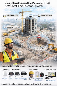
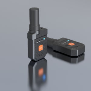
Limited real-time visibility of workers across dynamic job sites

Construction sites change daily, with rotating subcontractors and shifting work areas. Supervisors often lack precise, real-time knowledge of who is present, where they are located, and whether they are working in approved zones.

High risk of worker–vehicle collision

Excavators, trucks, forklifts and cranes operate close to pedestrian paths. Blind spots and congested areas frequently cause near-misses. Without precise location awareness, enforcing separation is difficult.

Difficulty managing access to hazardous or restricted zones

Areas such as crane swing zones, drop zones, energized electrical spaces, or work-at-height zones require strict access control. Manual monitoring is unreliable, especially during busy operations.

Manual attendance and subcontractor accountability

Paper-based check-ins and manual timekeeping are error-prone and easily manipulated. Contractors often dispute work hours, delays, and equipment usage without trusted location data.

Tool and material loss causing delays

High-value tools, pallets, and temporary assets often go missing on large sites. Without traceability, locating them quickly is difficult, resulting in project delays and increased rental costs.

Business drivers

Improve worker safety and reduce incidents

Automated geofencing, man-down alerts, and collision-avoidance systems help reduce accidents by providing real-time warnings and historical analytics.

Digitize workforce management

Real-time attendance, contractor time-on-site records, and movement logs reduce administrative work and increase transparency between general contractors and subcontractors.

Increase utilization of machinery and rented equipment

Location and operating-time data help reduce idle time, optimize scheduling, and lower unnecessary rental expenses.

Strengthen compliance and auditing

Location history, zone-entry logs, and automated reporting improve adherence to safety standards such as ISO 45001 and support regulatory audits.

📜 Regulations & safety expectations

Construction safety regulations in most markets require controlled access to hazardous areas, documented permits for high‑risk work, and reliable records of who is on site. An RTLS does not replace regulatory procedures, but it can automate much of the evidence‑gathering needed for audits and incident investigations.

GridRTLS can be configured to support local rules such as mandatory helmet use, restricted zones, working‑at‑height limitations or hot‑work perimeters, and to provide reports aligned with standards like ISO 45001 or your internal HSE framework. Final system design and data‑retention settings should always be reviewed with your local safety and legal teams.

🧩 Typical RTLS use cases

Common positioning and tracking scenarios for this industry.

Worker & Contractor Tracking

Construction crews frequently change locations throughout the day. RTLS automates attendance, validates contractor presence, and provides real-time visibility of workers across multi-level buildings and open yards.

Environment
mixed
Accuracy
0.3–1 m for personnel tracking
Update rate
1–2 s
Tracked objects
personnel, visitors_contractors
Typical integrations: Access control, HR systems, attendance & payroll, safety management systems

Vehicle & Heavy Equipment Collision Avoidance

Interactions between workers and machinery create high accident risk. UWB proximity alerts and GPS tracking reduce collisions by providing real-time warnings to both operators and pedestrians.

Environment
mixed
Accuracy
<30 cm for UWB proximity; 1–3 m for GPS outdoors
Update rate
1s
Tracked objects
personnel, vehicles, mobile_equipment
Typical integrations: Vehicle telematics, CCTV, HSE dashboards

Restricted Zone & Work-at-Height Access Control

Certain zones require special clearance. RTLS automates zone permissions and sends alerts when unauthorized personnel enter, improving compliance and reducing risk.

Environment
indoor
Accuracy
0.3–1 m
Update rate
1–3 s
Tracked objects
personnel
Typical integrations: Permit-to-work systems, access control, CCTV

📋 RTLS requirements for this industry

Typical coverage
Full active jobsite including building interiors (all levels), external laydown yards, temporary offices, camps and key access roads — typically 2–20 hectares depending on project phase. Coverage must expand as the structure grows and shrink again during demobilisation.
Personnel scale
From 50–200 workers on smaller building sites up to 2,000+ workers, supervisors and visitors on large civil or industrial projects. System capacity should be designed for at least 1.2–1.5× the expected peak headcount to allow for subcontractor overlap and emergencies.
Assets & vehicles
10–50 pieces of mobile plant on a medium site (cranes, excavators, dump trucks, concrete pumps, forklifts, MEWPs), plus 100–500 tagged tools, containers and temporary assets such as generators, lighting towers and formwork sets.
Environment constraints
Construction sites combine open outdoor areas and dense steel/concrete structures, with frequent changes to scaffolding, formwork and temporary buildings. RTLS equipment must tolerate dust, mud, vibration, rain and direct sunlight, and operate reliably between roughly –20 °C and +60 °C or more with IP66–IP67 ingress protection and, where required, intrinsically safe housings for explosive or petrochemical environments. Radio conditions are noisy due to welding, power tools and other wireless systems. UWB’s short‑pulse signals and wide spectrum help maintain accuracy and robustness in these conditions, while GPS/RTK receivers must keep lock in partially obstructed “urban canyon” geometries created by high‑rise structures.

🛡️ Safety & reliability expectations

Most construction use cases require sub‑meter accuracy to separate walkways, equipment zones and structural edges; safety‑critical features such as collision warnings and geofences benefit from ~30 cm precision delivered by UWB anchors and tags in line‑of‑sight conditions. GPS/RTK devices are used outdoors for machine guidance, vehicle tracking and structural monitoring; with differential corrections they can reach centimetre‑level accuracy where engineering decisions depend on small displacements.

The platform should support high availability (target 99.9% uptime during working hours), automatic failover of servers or gateways and buffering of tag data during temporary network loss. Wearables typically run for 1–3 months per charge at 1 Hz reporting, while battery‑powered UWB beacons can operate for up to five years, which is important when anchors are mounted on cranes or tall structures.

Safety logic — such as man‑down, evacuation and collision alerts — should be processed as close to the edge as possible to minimise latency.

Because RTLS data can be personally identifiable, projects should define retention periods, role‑based access rights and clear communication with workers and unions, aligning with local privacy laws and company policy.

🛰️ RTLS solutions for this industry

📦 Devices and infrastructure used in this industry

BQ Vehicle-Mounted Positioning Terminal

BQ Vehicle-Mounted Positioning Terminal

The BQ Vehicle-Mounted Positioning Terminal is an industrial-grade hybrid positioning device designed for vehicles operating in mines, construction sites, ports, transportation fleets, and harsh outdoor environments. It integrates UWB high-precision positioning, RTK centimeter-level positioning, GNSS multi-system outdoor tracking, 4G full-network communication, and features strong magnetic adsorption, anti-disassembly alarm, motion detection, TTS voice, and optional LoRa/5G modules. With a rugged IP66 design and a built-in 3000mAh rechargeable battery (optional 5000mAh), the BQ terminal ensures reliable real-time tracking and vehicle safety management in demanding industrial conditions.

View product
FZ Industrial Collision Avoidance Radar

FZ Industrial Collision Avoidance Radar

The FZ Collision Avoidance Radar is a high-precision industrial anti-collision device designed for vehicles, loaders, forklifts, cranes, and mining trucks. It supports a detection distance over 100 meters, 30 cm accuracy, dual-relay output, strong anti-interference capability, and IP67 protection for harsh industrial environments.

View product
SN2 UWB PoE Anchor

SN2 UWB PoE Anchor

The SN2 is an industrial‑grade UWB positioning anchor designed for high‑accuracy real‑time location systems. It supports Standard PoE or 12–24 V DC power, delivers sub‑meter performance (<30 cm LoS), and features an IP66 enclosure for harsh indoor/outdoor environments. Multiple mounting options (ceiling, wall, pole clamp) make deployment easy in factories, warehouses, and tunnels. Optional 4G/Wi‑Fi backhaul, AI video add‑on, and sound‑light alarm extend the anchor’s capability for safety and analytics. (Actual performance depends on anchor density, layout, and site RF conditions.)

View product
SW UWB Anchor

SW UWB Anchor

The SW UWB Positioning Base Station is an industrial-grade device designed for sub-meter accuracy tracking of personnel, vehicles, and assets in factories, tunnels, and other complex environments.

View product
URTC Vehicle-Mounted Hybrid Positioning Terminal

URTC Vehicle-Mounted Hybrid Positioning Terminal

The URTC Vehicle-Mounted Hybrid Positioning Terminal integrates RTK centimeter-level positioning, optional UWB <30 cm indoor positioning, and a GNSS full-constellation system, enabling high-precision positioning for industrial vehicles, engineering machinery, cranes, and fleet applications. With a separated-module design using coaxial cable connection, the URTC terminal achieves RTK accuracy of ±3 cm, supports 4G full-netcom communication, anti-collision functions, and performs reliably in harsh industrial environments with IP67 protection, wide temperature tolerance, and strong signal reception.

View product
TXWG Industrial Communication Gateway

TXWG Industrial Communication Gateway

A high-performance LPWAN-based industrial communication gateway designed for long-distance, low-power IoT communication. It supports LORA self-organizing networking, 4G cloud transmission, GPS time sync, multi-channel data forwarding, and explosion-proof applications.

View product
GNSS Differential Reference Station

GNSS Differential Reference Station

A high-precision GNSS/Beidou differential reference station that provides centimeter-level RTK corrections and sub-meter static accuracy. Supports RTCM differential data output, 4G/WiFi backhaul, UWB optional transmission, and fully integrates with positioning platforms for mining, ports, factories, and outdoor infrastructure.

View product
JCZD GNSS Displacement & Settlement Monitoring Terminal

JCZD GNSS Displacement & Settlement Monitoring Terminal

A high-precision GNSS-based monitoring terminal designed for real-time displacement and settlement monitoring in landslides, mining slopes, dam structures, reservoir embankments, tank subsidence, and roadbed deformation. Accuracy: ±2.5 mm horizontal / ±5 mm vertical. Supports GNSS differential positioning, 4G/RJ45 communication, fusion positioning algorithms, and outdoor IP67 deployment.

View product
URT Hybrid Positioning Terminal

URT Hybrid Positioning Terminal

The URT Hybrid Positioning Terminal is an industrial-grade wearable tracking device that integrates UWB high-precision positioning, RTK centimeter-level positioning, GPS outdoor positioning, and 4G wireless communication. It provides real-time personnel tracking, SOS emergency alerts, TTS voice broadcasting, motion detection, and optional NFC/Lora/5G expansion. With an IP66 rugged design and a 3000mAh magnetic-charging battery, the URT terminal is ideal for complex industrial environments such as factories, tunnels, construction sites, rail transit, and energy facilities.

View product
UBK UWB + GPS Hybrid Positioning Badge

UBK UWB + GPS Hybrid Positioning Badge

The UBK UWB + GPS Hybrid Positioning Badge is a rugged industrial-grade personnel tracking card designed for high-precision positioning in factories, warehouses, tunnels, and other demanding environments. It integrates UWB centimeter-level positioning with GPS outdoor positioning, features SOS emergency button, motion detection, TTS voice broadcast, 4G cellular communication, and optional NFC functionality. Equipped with a 3000mAh rechargeable battery and an IP66 protection rating, the UBK badge ensures reliable real-time personnel visibility and safety monitoring both indoors and outdoors.

View product
SH UWB Positioning Wristband Tag

SH UWB Positioning Wristband Tag

The SH UWB Positioning Wristband Tag is a high-precision wearable device designed for real-time personnel tracking and safety monitoring in industrial environments such as factories, construction sites, and tunnels.

View product
GP UWB Positioning Employee Card

GP UWB Positioning Employee Card

The GP UWB Positioning Employee Card is a compact, intelligent badge-style positioning device designed for industrial personnel management and safety monitoring. Built on UWB (Ultra-Wideband) technology, it achieves 10–30 cm accuracy, supports real-time location tracking, and enables instant SOS alerts via a one-touch button. The device includes vibration reminders, motion/static detection, and optional NFC/RFID, E-ink display, and LoRa communication modules. With an IP66-rated enclosure and 900 mAh rechargeable battery, it operates continuously in demanding environments such as factories, construction sites, logistics parks, and tunnels.

View product
AQM Hybrid Positioning Safety Helmet

AQM Hybrid Positioning Safety Helmet

The AQM Hybrid Positioning Safety Helmet is an industrial-grade smart helmet integrating UWB high-precision positioning, RTK centimeter-level positioning, GPS outdoor positioning, and 4G full-network communication. Designed for worker safety and real-time visibility, it features SOS emergency alerts, TTS voice, motion/static detection, low-battery warnings, and optional NFC / LoRa / 5G communication. With an IP56 rugged rating and a built-in 3000mAh rechargeable battery, the AQM helmet is ideal for construction sites, tunnels, factories, mining, ports, and hazardous environments requiring precise personnel tracking and safety protection.

View product

Frequently asked questions

What problems does an RTLS solve on construction sites? +
An RTLS gives live visibility of workers, vehicles and equipment across the jobsite. It reduces accidents, speeds up emergency response, automates attendance and zone‑access logs, and helps locate people and tools quickly when plans change.
How accurate is the system indoors and outdoors? +
Indoors we use UWB anchors and tags which typically deliver around 30 cm accuracy in open areas — enough to distinguish walkways, rooms and scaffold levels. Outdoors, GPS/RTK devices provide sub‑meter tracking for people and vehicles, and centimetre‑level accuracy when we need precise displacement monitoring or machine positioning.
Can the same tag work both indoors and outdoors? +
Yes. Hybrid GPS+UWB wearables (badges, helmets or handheld devices) switch automatically between UWB anchors indoors and GPS positioning outdoors, sending data over 4G/5G to the platform. Workers keep a single device as they move between laydown yards, buildings and partially covered areas.
Will RTLS interfere with cranes, radios or other site equipment? +
UWB operates in short, low‑power pulses that are designed to coexist with other radio systems. Our anchors and tags are built to industrial EMC standards and have been used around heavy machinery, welding and radio communications without issues. Each deployment includes a radio survey and pilot to validate performance on your specific site.
How fast can a construction RTLS be deployed? +
For a typical building site, core areas can be covered in a few days using a mix of wired anchors and battery‑powered UWB beacons that require no cabling. Additional floors or zones are added as the structure grows, and tags are issued to workers via self‑service charging/issuing stations that bind each device to a person in seconds.

Talk to us about your next construction site.

Share your site layout and safety priorities and we’ll design a UWB + GPS RTLS profile for your project — from pilot area to full‑site rollout. Our team can also map tags and zones to your existing HSE procedures, access control and BIM models.

48hr Response Time
Complete Integration Docs
Remote Setup Support

Ready to Deploy RTLS?

Share your site layout and accuracy needs--we'll suggest a practical setup.

Contact Us