Skip to content
Industrial UWB RTLS for Real-Time Visibility
Menu
Industry Solutions

Aviation & Airports
RTLS & Safety Solutions

Real-time visibility for baggage, ground support equipment and frontline staff.

GridRTLS helps airports track baggage, ULDs, ground support equipment (GSE) and frontline staff in real time — reducing delays, improving apron safety, and giving operations teams a live picture of what is happening on the ground.

Modern airports operate like small cities. Baggage moves through multi-level terminals and sortation systems, while hundreds of ground vehicles and frontline staff work around aircraft on congested aprons and service roads. Any blind spot in this environment can quickly turn into delays, safety incidents, or lost assets.

Traditional tools such as radios, CCTV and manual checklists provide only partial visibility. Operations managers often cannot see where baggage, ULDs, GSE or key staff are at a given moment, especially across remote stands, bus gates and outlying facilities. This makes it hard to prevent bottlenecks, investigate incidents, or optimize resource utilization.

By combining UWB, GNSS RTK and hybrid RTLS technologies, GridRTLS creates a real-time digital twin of airport ground operations. Baggage carts, ULDs, tugs, loaders, buses, fuel trucks and key personnel can all be located on a single map, indoors and outdoors, with sub-meter accuracy.

This granular visibility supports safer apron operations, faster turnarounds, better utilization of ground support equipment, and data-driven collaboration between airlines, ground handlers and the airport operator.

📊 Key stats for this industry

Typical airport campus size
5–15 km²

Multi-level terminals, aprons, taxiways and remote stands

Ground service vehicles to be tracked
100–500 units

Tugs, belt loaders, buses, fuel trucks, de-icing and maintenance vehicles

Frontline staff on airside per shift
500–3,000 people

Ramp agents, baggage handlers, drivers, maintenance and safety teams

Typical positioning accuracy target
≤ 1 m

Sub-meter accuracy on aprons and in baggage areas for critical use cases

⚠︎

Operational challenges

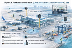
Limited visibility of baggage and ULD location

Baggage moves through sortation systems, make-up areas, dollies and carts on the apron. When bags or ULDs are misplaced, there is often no real-time view of where they were last seen or which cart they are on. This leads to last-minute searches, mis-loads and delayed departures.

Safety risks for staff and vehicles on the apron

The apron is a dense environment with aircraft, fuel trucks, buses, belt loaders and pedestrians working in close proximity, often at night or in poor weather. Without precise location data and geofenced alerts, near-misses and collisions between vehicles, equipment and people are difficult to prevent and investigate.

Manual coordination and radio congestion

Many ground operations still rely on voice radio to coordinate vehicles and staff. Controllers have to juggle multiple channels without a live map of asset locations, leading to inefficient dispatching, idle GSE and longer turnaround times.

Fragmented data across multiple systems

Information about flights, baggage, GSE and staff is often spread across separate systems: AODB, FIDS, baggage handling, workforce management and security. Without a common real-time location layer, it is hard to correlate events and optimize operations end-to-end.

Business drivers

On-time performance and turnaround pressure

Airlines and ground handlers are under constant pressure to improve on-time performance while handling growing traffic and complex schedules. Real-time visibility of baggage, GSE and staff enables more predictable turnarounds and fewer last-minute disruptions at the gate.

Runway and apron safety requirements

Regulators and airport operators set strict targets for runway incursions, apron incidents and worker safety. RTLS helps enforce speed limits, restricted zones and safe separation between vehicles, aircraft and personnel.

Digitalization and A-CDM integration

Many airports are implementing Airport Collaborative Decision Making (A-CDM) and other digital initiatives. A unified positioning layer feeds accurate time-stamped events — such as “GSE on stand” or “baggage delivery completed” — into these systems for better planning and analytics.

📜 Regulations & safety expectations

Aviation safety bodies and airport operators typically require strict control of vehicle access, speed and movement on airside roads and aprons. Ground handling activities must comply with local safety rules for working around aircraft, hazardous areas and fuel facilities.

While specific regulations differ by country and operator, many airports now expect detailed logs of who and what entered restricted zones, how long they stayed, and how incidents can be reconstructed. RTLS provides a reliable data source to support such reporting, training and continuous improvement.

🧩 Typical RTLS use cases

Common positioning and tracking scenarios for this industry.

Baggage and ULD tracking from hall to aircraft

Track baggage carts, ULDs and high-value bags as they move through baggage halls, make-up areas and out to the apron. Real-time positions and last-seen locations help prevent mis-loads, reduce manual searching, and support fast recovery when bags are delayed or misrouted.

Environment
mixed
Accuracy
0.3–0.5 m in baggage halls and make-up areas; 0.5–1.5 m on aprons and service roads.
Update rate
1–3 s
Tracked objects
vehicles, mobile_equipment, materials_inventory
Typical integrations: Baggage handling and sortation systems, AODB, flight information systems, CCTV and incident investigation tools.

Ground support equipment (GSE) tracking and utilization

Track tugs, belt loaders, passenger stairs, GPUs, de-icing trucks and other GSE in real time. Operations teams can quickly locate the nearest available equipment, balance usage across the fleet, and analyse idle time versus productive time.

Environment
outdoor
Accuracy
0.5–1.5 m for vehicles on aprons, stands and airside service roads.
Update rate
1–5 s
Tracked objects
vehicles, mobile_equipment
Typical integrations: GSE maintenance and asset management systems, dispatch consoles, A-CDM and turnaround management tools.

Apron vehicle anti-collision and speed enforcement

Use precise RTLS data to generate proximity and geofence alerts when vehicles or equipment approach aircraft, fuel farms or restricted zones at unsafe speed. Historical trajectories help investigate incidents and support safety training.

Environment
outdoor
Accuracy
0.5–1 m for vehicles and people in high-risk apron zones.
Update rate
1–2 s
Tracked objects
vehicles
Typical integrations: Safety monitoring systems, in-vehicle terminals, control room dashboards and video systems.

Frontline staff safety and mustering

Equip ramp agents, technicians and supervisors with RTLS tags to improve personal safety in high-risk areas. The system can trigger alarms if staff enter restricted zones, remain too long in hazardous areas, or need to be located quickly during emergencies and drills.

Environment
mixed
Accuracy
0.5–1 m in critical areas such as stands, fuel facilities and maintenance zones.
Update rate
1–3 s
Tracked objects
personnel, visitors_contractors
Typical integrations: Access control, emergency response systems, radio / Push-to-Talk platforms and training records.

Turnaround milestone and A-CDM event tracking

Use RTLS events — such as GSE arriving on stand, baggage off-loading started, fuelling completed — to automatically generate turnaround milestones. These events can feed A-CDM systems and airline dashboards, improving forecast off-block and departure times.

Environment
mixed
Accuracy
Sub-meter accuracy around stands; meter-level accuracy elsewhere on the apron.
Update rate
1–5 s
Tracked objects
personnel, vehicles, mobile_equipment
Typical integrations: A-CDM platforms, AODB, airline operations control, turnaround management tools.

📋 RTLS requirements for this industry

Typical coverage
From multi-level terminal buildings and baggage halls to aprons, taxiways and remote stands — typically covering 5–15 km² of airside and landside operational areas.
Personnel scale
Hundreds to several thousand frontline workers per day, including ramp agents, baggage handlers, drivers, maintenance crews, fuelling teams and safety officers.
Assets & vehicles
From 100 to over 1,000 tracked assets, such as tugs, belt loaders, buses, fuel trucks, de-icing vehicles, ULDs, baggage carts and specialized maintenance equipment.
Environment constraints
Strong multipath and RF reflections around aircraft bodies and metal structures; mixed indoor–outdoor coverage; exposure to rain, snow, heat and low temperatures on the apron; radio congestion from existing Wi-Fi, TETRA and other wireless systems; strict safety and security rules for any equipment installed near aircraft and fuel facilities.

🛡️ Safety & reliability expectations

The RTLS infrastructure must operate reliably in mission-critical environments where safety and punctuality are directly linked to system performance. High availability, redundant positioning references, and graceful degradation in case of network or GNSS outages are essential.

The system should support buffered tag data when moving through coverage gaps, clear alarm and event logs for investigations, and integration with airport cybersecurity and safety policies. Hardware installed on airside must meet local certification, environmental and, where applicable, explosive-atmosphere requirements.

🛰️ RTLS solutions for this industry

📦 Devices and infrastructure used in this industry

SN2 UWB PoE Anchor

SN2 UWB PoE Anchor

The SN2 is an industrial‑grade UWB positioning anchor designed for high‑accuracy real‑time location systems. It supports Standard PoE or 12–24 V DC power, delivers sub‑meter performance (<30 cm LoS), and features an IP66 enclosure for harsh indoor/outdoor environments. Multiple mounting options (ceiling, wall, pole clamp) make deployment easy in factories, warehouses, and tunnels. Optional 4G/Wi‑Fi backhaul, AI video add‑on, and sound‑light alarm extend the anchor’s capability for safety and analytics. (Actual performance depends on anchor density, layout, and site RF conditions.)

View product
SW UWB Anchor

SW UWB Anchor

The SW UWB Positioning Base Station is an industrial-grade device designed for sub-meter accuracy tracking of personnel, vehicles, and assets in factories, tunnels, and other complex environments.

View product
SH UWB Positioning Wristband Tag

SH UWB Positioning Wristband Tag

The SH UWB Positioning Wristband Tag is a high-precision wearable device designed for real-time personnel tracking and safety monitoring in industrial environments such as factories, construction sites, and tunnels.

View product
GP UWB Positioning Employee Card

GP UWB Positioning Employee Card

The GP UWB Positioning Employee Card is a compact, intelligent badge-style positioning device designed for industrial personnel management and safety monitoring. Built on UWB (Ultra-Wideband) technology, it achieves 10–30 cm accuracy, supports real-time location tracking, and enables instant SOS alerts via a one-touch button. The device includes vibration reminders, motion/static detection, and optional NFC/RFID, E-ink display, and LoRa communication modules. With an IP66-rated enclosure and 900 mAh rechargeable battery, it operates continuously in demanding environments such as factories, construction sites, logistics parks, and tunnels.

View product
UBK UWB + GPS Hybrid Positioning Badge

UBK UWB + GPS Hybrid Positioning Badge

The UBK UWB + GPS Hybrid Positioning Badge is a rugged industrial-grade personnel tracking card designed for high-precision positioning in factories, warehouses, tunnels, and other demanding environments. It integrates UWB centimeter-level positioning with GPS outdoor positioning, features SOS emergency button, motion detection, TTS voice broadcast, 4G cellular communication, and optional NFC functionality. Equipped with a 3000mAh rechargeable battery and an IP66 protection rating, the UBK badge ensures reliable real-time personnel visibility and safety monitoring both indoors and outdoors.

View product
URT Hybrid Positioning Terminal

URT Hybrid Positioning Terminal

The URT Hybrid Positioning Terminal is an industrial-grade wearable tracking device that integrates UWB high-precision positioning, RTK centimeter-level positioning, GPS outdoor positioning, and 4G wireless communication. It provides real-time personnel tracking, SOS emergency alerts, TTS voice broadcasting, motion detection, and optional NFC/Lora/5G expansion. With an IP66 rugged design and a 3000mAh magnetic-charging battery, the URT terminal is ideal for complex industrial environments such as factories, tunnels, construction sites, rail transit, and energy facilities.

View product
TXWG Industrial Communication Gateway

TXWG Industrial Communication Gateway

A high-performance LPWAN-based industrial communication gateway designed for long-distance, low-power IoT communication. It supports LORA self-organizing networking, 4G cloud transmission, GPS time sync, multi-channel data forwarding, and explosion-proof applications.

View product

Frequently asked questions

What problems can RTLS solve for airports and ground handlers? +
RTLS gives airports and ground handlers real-time visibility of baggage, ULDs, GSE and frontline staff. This helps reduce lost or delayed bags, improve turnaround reliability, prevent apron incidents, and provide accurate time-stamped data for investigations and continuous improvement.
Can RTLS be deployed safely in airside and restricted zones? +
Yes. RTLS infrastructure and tags can be designed to meet airport safety and RF requirements, including operation near aircraft and fuel facilities. GridRTLS uses certified hardware, controlled transmit power and appropriate installation practices to comply with local regulations and operator policies.
What positioning accuracy is realistic for airport RTLS deployments? +
For most airport use cases, sub-meter accuracy on aprons and in baggage areas is sufficient to support safety, utilization and process optimization. GridRTLS combines UWB and GNSS RTK to deliver around 0.3–0.5 m accuracy in critical indoor zones and 0.5–1.5 m accuracy outdoors, depending on the environment.
How does RTLS integrate with existing airport IT systems? +
RTLS can feed live events and location data into AODB, A-CDM platforms, baggage handling systems, workforce management tools and safety dashboards via open APIs. This turns location information into actionable events such as “GSE on stand”, “baggage off-loading started” or “vehicle entered restricted zone”.
What is the typical deployment approach for an airport? +
Most airports start with a focused use case, such as baggage and GSE tracking on selected aprons, and then expand coverage to terminal buildings, remote stands and other facilities. GridRTLS supports a phased deployment model, allowing you to reuse infrastructure and gradually onboard more assets and processes.

Plan a unified RTLS blueprint for your airport.

Talk to our team about how UWB and GNSS RTLS can improve your apron safety, baggage handling and GSE utilization. We can help you design a phased rollout that fits your airport’s operations, IT systems and regulatory requirements.

48hr Response Time
Complete Integration Docs
Remote Setup Support

Ready to Deploy RTLS?

Share your site layout and accuracy needs--we'll suggest a practical setup.

Contact Us