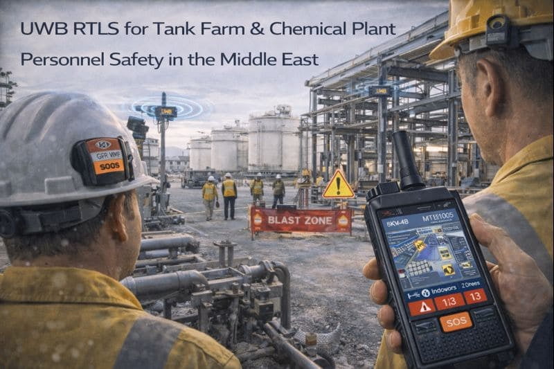
UWB RTLS for Tank Farm & Chemical Plant Personnel Safety in the Middle East
Real-time UWB + GPS RTLS cuts muster time by 75% and brings high‑risk process areas under
Key Stats
KPIs (Before vs After)
| Metric | Before | After |
|---|---|---|
| Average time to confirm full headcount during emergency drills | 18–22 minutes per drill (baseline 2023) | |
| Recorded vehicle–pedestrian near‑miss events in tank farm and loading racks | 3 incidents per month (12‑month average) | |
| Typical time to locate a specific contractor or work team on site | 10–15 minutes | |
| Permits with accurate zone‑level time‑on‑site data | <10 % of permits | |
| Time to confirm 98% of headcount during muster drills | 4–6 minutes | |
| Vehicle–pedestrian near‑miss events in tank farm and loading racks | <1 incident per month (rolling 12‑month average) | |
| Time to locate any tagged employee or contractor | <1 minute via RTLS console | |
| Permits with reliable zone‑level time‑on‑site records | >95 % of permits |
Overview
An integrated petrochemical complex in the Middle East needed a way to protect workers across dense process units, a large tank farm and busy truck and marine loading areas.
GridRTLS deployed a combined UWB + GPS real‑time location system (RTLS) that gives HSE and operations teams live visibility of every tagged worker and vehicle, enforces electronic safety zones around major hazards, and automates emergency mustering.
Customer Background
The client operates a continuous‑process refinery and petrochemical plant with more than 140 hectares of assets, including atmospheric and vacuum distillation, downstream process units, a tank farm with over 80 above‑ground tanks, and truck and jetty loading facilities.
On a typical day, around 450 employees and 200 contractors are on site across three main areas. Turnarounds and brownfield projects can easily double the number of people in the plant, while traffic through the loading terminal remains high.
The site is regulated under Seveso‑type major accident hazard legislation and follows international process‑safety standards. The operator already had mature procedures for work permits, confined‑space entry and hot work, but lacked reliable real‑time location information to support those processes, especially in outdoor tank farms and multi‑level pipe racks.
Challenges
The RTLS project was initiated after several audit findings and near‑misses highlighted gaps:
-
Slow and manual mustering. Muster lists were based on access‑control logs and radio check‑ins. Accounting for everyone during drills routinely took close to 20 minutes, especially when contractors moved between process units and the tank farm.
-
Limited visibility in high‑risk zones. HSE could not easily see how many people were inside each tank bund, loading rack or restricted unit, nor how long they had been there. Major hazard zones and “silent areas” (where phones and radios are restricted) were effectively blind spots.
-
Vehicle–pedestrian interaction risks. Forklifts, tank trucks and maintenance vehicles shared narrow lanes with foot traffic. Near‑miss incident data showed that most events occurred where visibility was poor – between tanks, under pipe racks and on night shifts.
-
Fragmented systems. CCTV, access control, gas detection and work permit tools all operated independently. There was no single view combining “who is where” with live video and alarm data.
-
Challenging environment. Classified hazardous areas required explosion‑proof equipment, RF coexistence with existing Wi‑Fi and radio systems, and reliable performance under metal structures, dense pipework and complex reflections.
The customer wanted a solution that would work seamlessly across indoor control buildings, congested process units and open tank farms – and that could later extend to other global sites.
Solution
The site selected the GridRTLS Chemical & Tank Farm Personnel Safety solution, built on UWB RTLS for high‑density areas and GPS/RTK for open outdoor spaces.
Key design elements:
-
UWB RTLS in process units and tank farm. Explosion‑proof UWB anchors with IP67 protection were mounted on columns, pipe racks and tank shells to create a dense 2D/3D positioning grid with 10–30 cm accuracy at 1 Hz for personnel and up to 10 Hz for vehicles.
-
GPS/RTK for yards and access roads. A differential GNSS reference station on a stable rooftop provides centimetre‑level corrections over a 15–20 km radius. Vehicle and hybrid personnel tags use this feed for high‑accuracy positioning on roads and open staging areas.
-
Fusion tags for seamless indoor–outdoor transitions. Workers in high‑risk roles carry rugged UWB/GNSS badges or helmet tags with integrated LTE and SOS buttons. Outdoors, tags rely on GPS/RTK; indoors and around steel structures they automatically fall back to UWB trilateration without user action.
-
Vehicle RTLS & collision‑avoidance. Tank trucks, yard tractors and forklifts are fitted with vehicle RTLS terminals. These combine RTK‑grade GNSS with UWB ranging to nearby personnel tags and other vehicles, enabling speed‑ and distance‑based alarms as well as fine‑grained position tracking near loading racks and between tanks.
-
Safety‑centric applications. The RTLS platform provides a 3D site map with live positions, historical track playback, virtual electronic fences and alarm management, similar to the system functions deployed by the supplier in Chinese chemical and industrial sites.
The RTLS server is hosted on‑premises in the control building, integrated with the plant network, CCTV video management system and the customer’s digital permit‑to‑work tool through open REST APIs.
Implementation
The project was executed in three main phases over six months, without disrupting production:
-
Design, modelling and pilot.
GridRTLS engineers ingested P&IDs, 3D models and layout drawings to define safety‑critical zones: tank bunds, loading racks, pump rooms, process units, compressor buildings and shelter‑in‑place areas. For each zone, they modelled UWB coverage, anchor density and line‑of‑sight constraints, choosing wired explosion‑proof anchors in hazardous areas and battery beacons on non‑hazardous structures where wiring would be difficult. -
Infrastructure deployment.
-
~120 wired UWB anchors were installed in process units, compressor houses and the tank farm, powered over industrial PoE switches on a segregated VLAN.
-
45 battery‑powered beacons extended coverage along pipe racks, stairwells and around remote tanks where no network drops existed.
-
A single differential GNSS reference station was mounted on a roof, with redundant power and LTE backhaul.
-
Two communication gateways were installed to bridge RTLS data from zones that cannot use public mobile networks to the main server over private microwave links.
-
-
Tag rollout and integration.
-
520 employees received UWB/GNSS smart badges or helmet tags with SOS and man‑down detection; long‑term contractors received similar devices configured with different access rules and reporting profiles.
-
70 vehicles were equipped with RTLS units interlocked to sound‑and‑light alarms and, for some forklifts, to speed‑limiting relays triggered when entering pedestrian priority zones.
-
The RTLS server was integrated with the digital permit‑to‑work system so that each permit references a list of expected workers and zones, enabling automatic checks for unauthorized entries.
-
CCTV cameras at tank farms and loading racks were mapped to RTLS zones, so that alarms (e.g. unauthorized entry, lone worker in “silent” area, SOS) automatically pull up live video for control‑room operators.
-
-
Configuration of safety logic and training.
HSE configured virtual fences around major hazard installations and defined rules such as:-
only authorized roles may enter a given zone;
-
alarms for overcrowding inside a bund or pump room;
-
overtime alerts when workers remain in hot zones beyond the planned permit duration.
Control room staff, permit issuers and emergency response teams were trained using scenario‑based drills including tank‑farm leaks, confined‑space incidents and night‑shift evacuations.
-
Results
Within the first year of operation, the site saw significant safety and productivity gains:
-
Emergency mustering time cut by ~75%.
Because the RTLS platform constantly tracks who has badged into the plant and their last known zone, the system can automatically mark people as “accounted for” when they reach muster points. HSE now confirms 98% of headcount within 4–6 minutes during drills, down from nearly 20 minutes previously. -
Better control of high‑risk zones.
Virtual fences around tank bunds, flare areas, pump rooms and other major hazard zones now enforce role‑based access and dwell‑time limits. Unauthorized entry, overcrowding or overstaying in these zones generates alarms, enabling intervention before risky situations escalate. -
Reduced vehicle–pedestrian near misses.
The combination of vehicle RTLS, proximity detection and speed‑limited zones has cut recorded near‑miss events in the tank farm from around three per month to fewer than one, with clear incident replays available for root‑cause analysis. -
Higher‑quality permit and inspection data.
Each work permit now has objective, time‑stamped data on who entered which zone and for how long. This supports post‑job reviews, contractor performance management and optimization of inspection routes and man‑hours. -
Foundation for broader digitalization.
Because the RTLS exposes standardized APIs, the client has already begun using the same location data for predictive maintenance (e.g. correlating technician routes with recurring equipment failures) and for planning future brownfield projects.
Overall, the project turned a previously “blind” tank farm and process area into a safety‑instrumented, data‑rich environment, while staying compatible with the client’s strict hazardous‑area and cybersecurity requirements.
Quote
“For the first time we have a live, zone‑level view of who is working where across the entire complex. During a drill we can see people flowing into muster points in real time, and in day‑to‑day operations we can spot unauthorized entries or overcrowding in high‑risk areas before they turn into incidents.”<br />
— HSE Manager, Integrated Petrochemical Complex (anonymised)
Related Solutions
Related Products
Want a similar deployment?
Share your site type, tag count, coverage area, and safety requirements. We’ll recommend a UWB / GNSS design and a rollout plan.